|
|
Legacy Sailing |
|||||||||||||||
| Tenacatita and Barra de Navidad | ||||||||||||||||
|
The Trip On-line Log Calendar The
Boat
Sea Stories
|
CAUTION: All the usual disclaimers apply. You are responsible
for the safe navigation of your vessel. These waypoints and other
information are offered to assist you, however you should always cross check
them against other sources and using your own eyeballs, instrumentation, and
good judgment.
The information below this point is dated. For the latest Tenacatita and Barra Guide updated March 2013 click here. Information available on Tenacatita and Barra de Navidad:
General Info - Tenacatita & Barra Geographic info – Tenacatita Main Beach and palapa: The main beach is the sandy beach on the north side of the anchorage. The main dinghy landing is just to the right of the bluff on the beach. The palapa is on the far left end of the beach tucked into the grove of palm trees. The Blue Bay Hotel is on the far right end of the beach. Jungle River Trip: The entrance to the jungle river is at the left end of the main beach between the reef and the palapa. Entrance to the river is easier at plus tides. It is also possible to enter the river over the reef at the base of the bluff at +1 foot tides. This route may avoid breaking seas in the river mouth and the worst of the shallows. Dodge the submerged rocks. At very low tides you may want to land the dinghy on the main beach and roll it along until you can relaunch in front of the palapa. The jungle river trip is about 2 ½ miles through the mangroves and dead-ends at the dinghy landing on the lagoon side of Playa Tenacatita. A 20-peso dinghy parking fee is sometimes collected. There are restaurants and a well stocked small tienda there. The small town of Revelcito is about 3 km up the road from Playa Tenacatita. Trails: There are a number of trails near Tenacatita suitable for walkers, runners, or mountain riders. From the center of Good Dog Beach a rough trail leads a couple of hundred yards into the bush where it meets a rough jeep road. To the left this road leads about 2 ½ miles over the hills to the east end of Playa Tenacatita. To the right this road reaches the river opposite the panga dock. From behind the horse stables by the Blue Bay Hotel a jeep trail leads north, bears left around the mangroves, and eventually reaches Revelcito at about 4.5 miles. Go left to reach Playa Tenacatita. A long circuit can be made by combining these two trails. Alternate Anchorages: In strong southerly weather boats may find protected anchorage off La Manzanilla or off the Tamarindo Resort beach. Services - Tenacatita Palapa – “La Vena”: Has good food and beverages, and is open until about 5 pm – closed Tuesday. Provisions: Provisions can be obtained in La Manzanilla or at the small tienda in Playa Tenacatita at the far end of the jungle river trip. Laundry: Laundry can sometimes be arranged through the palapa. Fuel: Jugs of fuel can sometimes be supplied by the palapa. At times, cruisers have obtained small quantities of fuel through the Fiesta Mexicana restaurant in Playa Tenacatita. Otherwise, there is a fuel dock in Barra. Water and ice: It is sometimes possible to arrange purchase of water and/or ice through the palapa. Both are available at Playa Tenacatita and La Manzanilla. Internet and Telephone: Available in La Manzanilla. Blue Bay Hotel (their computer) for US$5 per half hour. Unsecured WiFi access points in the anchorage and off La Manzanilla with hi-gain antenna, sporadic. Tel-Mex (Cingular) cell phone service. Blue Bay Hotel: This is an all-inclusive resort which discourages visitors. Day-passes are available at the front desk. Navigation Information – La
Manzanilla Anchorage: Exposed to the NW; large swell and wind, especially in the afternoon. Anchor off the main part of town. The cove at the south end of town is shallow and foul. Holding appears to be good. Viable anchorage in strong SE winds. Dinghy Landing: Troublesome surf landing dampens many. Many cruisers pack their clothes and groceries in dry bags and expect to get wet coming or going. The break is generally milder in the morning and builds rapidly after noon as the NW wind builds. Alternatively you can get a cab from the Blue Bay Hotel and return in three hours for about MX $300 for four persons. Services - La Manzanilla Restaurants: Several good restaurants are available. Cruiser favorites include Palapa Joes (big screen TV for sports) and Martin’s Restaurant for French inspired Mexican dishes (off the SW corner of the plaza). Medical: The pharmacia is run by Dr. Martha who can handle simple medical problems. Book Exchange: A small book exchange supporting local youth programs is located a few doors south of the plaza on one of the side streets. Cocodrillos: A large number of caimans can be seen from the viewing area at the north end of town or from the beachfront road. Transportation: Bus service to Melaque starts at 8:30am and runs about every two hours until late afternoon / early evening. Taxi service also available. Assistance: Larry and Nancy of Casa Alegre (yellow house on the beach in the middle of town) often monitor the morning net and can provide information concerning La Manzanilla. Navigation Information – Barra de
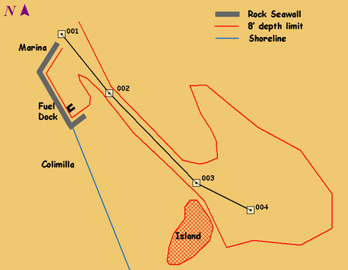
Navidad Barra Fuel Dock: There are no channel markers beyond the marina. The fuel dock is past the marina to starboard in the lagoon. To go to the fuel dock you should run parallel to the breakwater and then make a turn and stay parallel to the wall leading to the fuel dock. There is a large shoal between the lagoon anchorage channel and the fuel dock that runs from near the island to near the marina breakwater. (See the chartlet on page 3.) Sometimes there are a couple of floats north of the fuel dock marking the cable crossing – no obstruction here. Grand Bay Marina: The marina monitors channel 16, though they are not good about responding to radio calls. Calling someone already in the Marina and asking them to check with the office for a slip may be more reliable. Cruisers have had good luck just going in and taking an open slip on G dock and reporting to the office after-the-fact. In 2007, the marina rate was about US$2/foot/night. Lagoon Anchorage: To reach the anchorage area in the lagoon you must start in the channel running from the breakwater by the marina entrance to the island in the lagoon. The channel is approximately 12 feet deep at zero tide and is very uniform in depth. The sides of the channel are very steep, so any depths in the 9 foot range indicate imminent grounding. See the diagram, Legacy’s waypoints, and the details of Kavenga’s survey of the channel and limits of the anchorage on page 3. Colimilla – Barra Lagoon: This is the small village on the eastern shore of the lagoon just past the fuel dock. As well as several good restaurants this is also the location of Maria’s Tienda. The outboard service business on the beach does stainless welding. Barra – Landing and Local Transport: Water taxis are available for local transportation. Call “Taxi Aquatico” on channel 23. Fare is about 20 pesos roundtrip between the marina and Barra, and 25 pesos roundtrip between the lagoon and Barra. You can also take your dinghy to Barra. Land your dinghy at the Hotel Sands and tie it along the seawall. Leave your motor down to avoid damage to other dinghies, and consider a stern anchor to hold you off the wall. From Barra, you can take a 4 peso bus or a 50 peso taxi to Melaque. The Manzanillo Airport is accessible only by taxi (no bus). About 250 pesos from Barra or 500 pesos from the Grand Bay. Services – Barra de Navidad
Water: Available at the fuel dock or contact Maria’s Tienda for bottled water delivery. Propane: Contact Maria’s Tienda on channel 77. Provisions: There are many small tiendas and pescaderias in Barra. The veggie trucks in Barra offer very nice produce. Look for them along Vera Cruz. Melaque has more and larger stores. Especially notable is Super Hawaii which specializes in gringo foods. Maria’s Tienda in the village of Colimilla has most items that cruisers want, and she will also do special orders. Contact Maria on channel 77. To find her tienda, dock your dinghy on the beach near Restaurant Colimilla, walk up the street one block, and turn right. Maria’s Tienda is a half block on the right near Fortino’s Restaurant. Ask Maria for directions to her uncle’s pescadaria also in Colimilla. French Baker: Delivers fresh croissants, baguettes, and pies by panga in the marina and the lagoon each morning between 8:30 and 9:30. Will accept advance orders either when he delivers, or at his stores in Barra and Melaque. Pool: Cruisers are reportedly welcome to use the pool at the Hotel Sands if they buy drinks or food. ATM: There is an ATM behind the concierge desk in the lobby of the Grand Bay Resort, and one on Veracruz in Barra de Navidad. Internet: In Barra on first floor of large hotel on Vera Cruz up from “the big tree.” Wi-Fi purchased from the Grand Bay in the marina also in the lagoon with hi-gain antenna. Free internet at Piper’s on the beach. Hardware stores, bank, and other services: Outboard repair shops and a small ferreteria in Barra. Hardware, welding, electrical repair and a bank are available in Melaque. Useful Information and Phone Numbers Dentist: In Barra Dr. Laura is recommended. 355-6179 Veterinarian: In Melaque “Beto” phone 355-6782 (ofc) 355-6238 (hm) Cuastacomantes – “The Secret
Anchorage” Legacy’s approach waypoint 19 13.47 N 104 44.61 W Electronic Navigation
Updated February 22, 2007 In 2004 Kavenga conducted a survey of the Barra lagoon anchorage and the channel leading into to determine where the 8 foot depth contour was located. This survey was suplemented in 2006 by Legacy's surveys of the island in the lagoon and the approach to the fuel dock. The results of these surveys and Legacy's route into the lagoon are shown on this chartlet. The details of the surveys follow.
Kavenga’s Barra Lagoon Channel and Anchorage Waypoints These virtual buoys consist of soundings and corresponding GPS positions that were obtained on 12/25/2004 between 1305 and 1415 local time. According to one source, this timeframe corresponded to a tide range of +0.26 feet to -0.30 feet. So, for all practical purposes, it was a zero tide (just dumb luck, not design). Map Datum – WGS 84 All latitudes are 19 degrees, 11 minutes plus the fractional minute. To save keystrokes, only the fractional portions are given in the positions below. The waypoint ID numbers are the arbitrary numbers assigned automatically by our GPS and have no inherent meaning, other than it would make correcting and referencing them easier if any users should find significant discrepancies CHANNEL WAYPOINTS Wpt. 90 - .731N, .830W Wpt. 88 - .633N, .743W Wpt. 86 - .557N, .666W APPROACHING THE TURNING POINT Wpt 47 - 8' sounding - .467N, .583W LAGOON ANCHORAGE BOUNDARY Wpt. 50 - .399N, .511W The gaps in waypoint numbers are just soundings that were in a straight line between the soundings given and therefore not necessary to plot the 7-foot contour. “BACK ALLEY” ANCHORAGE In order to get there you first need to come all the way into the anchorage area, turn left, go past a line through the fish pen and parallel to the channel. You can then turn left again into this area. You can continue back towards town until you reach a line drawn from the fish pen shack to the point opposite it (to the ENE). The alley appears to be about 300 feet wide and possibly 1000 to 1200 feet long. So if a few boats anchored single file down the centerline of the alley, there should be plenty of swinging room since not much scope is needed (100’) in the shallow water. More soundings would be helpful, but it looks usable if the rest of the anchorage is already crowded. CON CUIDADO (CAUTION!) Fair seas, ADDENDUM – BARRA LAGOON ISLAND IS01 - .402N, 528W IS08 - .271N, .596W ADDENDUM – BARRA FUEL DOCK FD1 - .673N, .869W
|
|||||||||||||||
| Page update 12/28/2013 | ||||||||||||||||