|
|
Legacy Sailing |
| Technology | |
|
The Trip On-line Log Calendar The
Boat
Sea Stories
|
Legacy is a thoroughly modern lady, which is to
say that she is burdened with complex and inter-connected systems.
When they work, these systems make life a pleasure making navigation,
sailing, eating, and living aboard easier. The downside is that when
they fail or don't work as expected they create difficult to diagnose
problems and interesting repairs. While we enjoy our high tech
gadgets, we always have in the back of our mind a fall back system that does
not relay on high tech equipment. So we use electronic charts
extensively, but we always have paper back ups available. Since the
laptop is a critical element we carry two one in use and the second
configured with all the same software, but totally disconnected from ship's
systems. It can be plugged in as a substitute if the main system unit
fails. We also carry a complete autopilot system as a back up in case
of failure of parts or pieces of the autopilot. And of course we have
both spare handheld GPS receivers and a sextant and tables for true total
systems failures. That said, we do enjoy the benefits of technology.
Sailing Instrumentation
All of these instruments are connected to a Sea-Talk to NMEA interface through the network. This bidirectional interface allows NMEA data to be passed to the laptop computer running Nobeltec navigation software and for the laptop to pass steering corrections to the autopilot. Communications
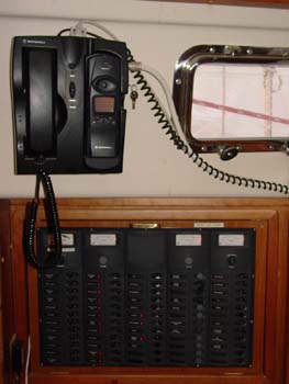
During our first season cruising we had a ICOM PCR 1000 SSB and FAX receiver. We found that listening in on the nets and weather forecasts was fun, but often wished that we could ask questions and pass traffic to boats far away. In the fall of 2004 we upgraded or SSB radio to a ICOM 802 transceiver. This radio has allowed us to communicate with folks as far away as Michigan and to participate regularly in the cruiser nets. Definitely a worthwhile addition. Many cruisers use Sailmail and Winlink over their radios for email, but we continue to use the Iridium phone for email. To add email capability to our radio we would have to purchase an expensive Pactor modem, so the additional expense does not seem warranted at this time. Although our radio covers the ham bands as well as the Marine SSB frequencies, we are not currently licensed to transmit on ham frequencies but can listen in. We were able to mount the control heads for the radio in the nav-station and put the radio itself in the aft cabin close to the batteries, antenna tuner, and far enough from all the other electronics to minimize interference. We use a 23 foot vertical whip antenna mounted on the starboard stern quarter and supported by the radar arch. Electronic Navigation Mexican charts in particular are quite inaccurate being based on surveys from the mid-1800s. Depending on where in Mexico you are the charts are between 1/4 and 1 mile offset. The relative position of objects shown on the chart are accurate, but the absolute position is wrong. Using the radar overlay (see below) we have built up a large number of waypoints and routes for Mexico that represent the ACTUAL position of critical objects. Using information recorded on previous trips means that we can approach and enter anchorages that might be too risky otherwise. Before using electronic navigation for critical navigation one needs to confirm its accuracy at this location and at this time with comparison to the real world. (Most of the maps and charts that you find on this site are created from edited screen shots from the Nobeltec display.) We also use Nobeltec Radar, which is a repackaged version of the Seitech Radar PC. We have found this to be a great system. The radar image can be overlaid on the chart so it is easy to discriminate land and fixed objects from those that might be boats or other objects. We have found that running a large scale chart view in one window and the radar in another window makes a great way to keep track of targets and keep in touch with the overall navigational picture. Radar makes running at night, around boat traffic, or in unfamiliar locations much more comfortable. To be useful, though, one must practice with the radar in good conditions to learn how to interpret and adjust the radar for when you really need it. We almost always run the radar when we are underway.
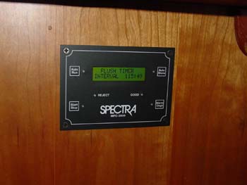
Watermaker
The Spectra Newport 400 produces about 15 gallons per hour drawing about 20 amps. Having a watermaker means that we don't worry about using water to wash dogs or ourselves. We have found that the watermaker is usable in almost any anchorage. The biggest issue is filter life in high particulate areas. We have found that we can rinse and reuse filters several times to extend their life and minimize the numbers we have to carry. Electrical Generation, Storage, and
Monitoring |
| Page update 10/05/2008 |
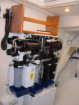 Installed
by Sound Rigging is a Spectra Newport 400 watermaker. After agonizing for several months over
installation location we elected to install it on the forward side of
the watertight shop bulkhead. This gives easy access to all of the
parts of the watermaker for maintenance and inspection. All of the
other alternatives required shoehorning the many parts and filters into a locker, making
future access problematic. Another benefit is that this frees up a
large locker for more storage, always a good thing. The Clark Pump and
reverse osmosis membranes are mounted on a heavy metal frame, making quite a
weighty block. Since we have the large bookcase on the other side of
the bulkhead we were able to through bolt the heavy components. We
also modified the workshop shelf to take a portion of the load as well. The
Installed
by Sound Rigging is a Spectra Newport 400 watermaker. After agonizing for several months over
installation location we elected to install it on the forward side of
the watertight shop bulkhead. This gives easy access to all of the
parts of the watermaker for maintenance and inspection. All of the
other alternatives required shoehorning the many parts and filters into a locker, making
future access problematic. Another benefit is that this frees up a
large locker for more storage, always a good thing. The Clark Pump and
reverse osmosis membranes are mounted on a heavy metal frame, making quite a
weighty block. Since we have the large bookcase on the other side of
the bulkhead we were able to through bolt the heavy components. We
also modified the workshop shelf to take a portion of the load as well. The